Topanga Course-Setter Notes
January 25, 2014
By Marvin Johnston KE6HTS
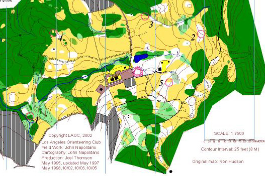
Course map with five transmitter locations marked. The location of #4 on the map was actually about 75
meters SSW of the location shown.
Course map with five transmitter locations marked. The location of #4 on the map was actually about 75
meters SSW of the location shown.
Per international rules, this course had five transmitters that were on for 60 seconds each in 1-2-3-4-5 rotating sequence. The least-distance order for finding them was 1-4-3-2-5. The concentric circles and triangle in the middle of the map show the start/finish location. Competitors started at five minute intervals as transmitter #1 came on the air and were told to head west through the parking lot.
Let's imagine that we are going out on the course. The first transmitter we hear and get a bearing on is #1. It should be a reasonable bearing showing the transmitter is west of the start/finish. Because it is the direction we are already headed, that appears to be the first transmitter to find. So we draw a line on the map on our bearing to #1.
On the way to #1, transmitter #2 comes on and our bearings show it to be in back of us and slightly towards the north. Again, we draw a line on the map from our current position towards our bearing to #2.
Still heading to #1, #3 comes on the air and our bearing is in back of us, north of the bearing to #2. So we draw a line from our current position to #3.
When #4 comes on the air, we get a bearing about due north of our current position and again draw a line towards #4.
Finally #5 comes on the air and our bearing shows it behind us. So we again draw a line from our current position towards #5.
At this point, we know #1 is the first transmitter to find, #4 is the second transmitter, #3 is the third transmitter, #2 is the fourth transmitter, and #5 is the last transmitter to find. We don't know their locations yet, but we have a good idea of the best order to find the transmitters.
Walking, our normal speed should be about 100 meters/minutes. So our position should be near the trail close to #1. When #1 comes on the air, we should have a really good bearing to it and should get it on the sixth minute.
We know #4 is the next transmitter and know the direction, but not the location. So we immediately head north on the trail and take a guess as to how far up it might be.
When #2 comes on the air, we still get a bearing to the east very close to our original bearing. So we continue.
#3 comes on the air and we notice the bearing is more clockwise from our original bearing. So we draw a line towards #3.
#4 comes on the air and our approximate location should be near or north of the fence. The bearing is still north, but much stronger, so we keep going toward #4. When it goes off the air, we are probably someone north of the fence heading up the hill. We note the area to the east is marked DO NOT ENTER as plant restoration is in progress. So we know it is on the west side of the trail heading north.
We should be able to pick up #4 on either the 14th minute when it is on the air, or maybe the 9th minute if we are running.
As we complete the course, we continue to take bearings and triangulate the locations of the other transmitters. We can be pretty sure our original guess of best order, 1-4-3-2-5 was correct and will proceed on that assumption.
Ideally with no mistakes or bad bearings (and running):
#1 is found on the sixth minute
#4 on the ninth or tenth (off cycle) minute
#3 on the 18th minute
#2 on the about the 24th minute or so (off cycle)
#5 is found on the 30th minute
Finish on the 32nd minute
This is a somewhat simplified description, but should give a basic idea of the strategy used to complete the course.
73,
Marvin Johnston KE6HTS
 Back to the Radio-Orienteering News for Southern California page
Back to the Homing In home page
This page updated 26 January 2014